How space tech scaleup Planet Labs is driving agricultural productivity
US space tech scaleup, Planet Labs’ fleet of approximately 200 mini satellites scan the Earth every day to provide daily high-resolution satellite imagery, and it’s arming landholders with the data to make more informed decisions. Farmer-owned co-operative, Organic Valley is reaping the rewards since teaming up with Planet Labs to develop a pasture mapping tool, that’s helped dairy farmers increase pasture utilisation by 20 per cent.
Looking to space to solve the world’s climate and biodiversity crises is what US space tech scaleup, Planet Labs, does best. Former NASA scientists, Will Marshall and Robbie Schingler, co-founded Planet Labs in 2010 and have grown from humble beginnings developing low-cost compact satellites in a Californian garage, to a multi-billion-dollar Public Benefit Corporation (PBC) – designed to accelerate humanity to a more sustainable, secure, and prosperous world by illuminating environmental and social change.
With over 34,000 users in 65 countries, Planet Labs’ satellite imaging service has democratised access to space, putting Earth observation data into the hands of local change-makers – from governments and NGOs to farmers – who use Planet Labs’ daily data to improve the way we manage our world.
High-resolution satellite imagery drives high impact farm decision-making
Planet Labs believes that, of all the inputs that can help farmers maximise yields, the most critical input is information. And while satellite data is becoming part of the modern farmer’s information toolkit, Planet Labs’ dataset is unique in the market.
Operating the world’s largest fleet of Earth imaging satellites, Planet Labs captures a daily snapshot of every inch of Earth’s landmass. Planet Labs Country Manager for Australia, Tristan Dowler, explained, “Our 200 CubeSats [square-shaped nanosatellites] capture around 4 million images every day. Each about the size of a loaf of bread, they fly in a sun synchronous orbit around the planet, providing farmers and their service providers with a bird’s eye view of paddocks throughout the growing season – enabling them to detect issues as they arise, and make proactive management decisions to improve yield outcomes.”
Frequency of image capture is one advantage Planet Labs has over its competitors. The other is the clarity of its imagery.
“Traditionally, satellite data available to farmers has been from the European Space Agency’s Sentinel or NASA’s Landsat – big public datasets with upwards of 60 metre resolution,” said Tristan. “Such coarse imagery doesn’t allow for paddock level decision-making – the finer applications that allow farmers to extract real insight and value.”
Extracting that insight is easy, with Planet Labs offering seamless integration of analysis-ready data into a growing range of digital agricultural applications geared towards improved farm decision-making.
Satellite options allow agribusinesses to select the image resolution they need
Planet Labs currently offers two optical constellations, both of which are richer in detail than traditional satellite imagery. “Farmers find our PlanetScope product most compelling,” said Tristan. “It provides 3.7m resolution that enables informed crop selection and seeding, crop health monitoring and management, and harvest and yield optimisation.”
Another constellation, SkySat, offers market-leading spatial resolution down to 50 centimetres – enabling advanced functions like the development of automated crop growth detection systems.
“SkySat lets farmers see their farm in detail so fine that they can tell whether a silo lid is on or off,” added Tristan.
And now a new constellation, Pelican, will change the game again – offering 30cm resolution on launch in 2023.
Living dataset of global change – at the local level
Planet Labs has been collecting data on every inch of the Earth since 2016, compiling a rich living dataset of global landuse change. More than 10 billion square kilometres of imagery is available to subscribers, with new imagery added just hours after capture.
“Planet Archive contains on average 1,800 images for every point on Earth,” said Tristan. “Farmers can travel back in time to understand historical productivity, and plan for improved crop choice, fertiliser use, or irrigation that takes that into account.”
The rich dataset and ease of integration has seen Planet Labs become the world’s largest commercial imagery provider to the agriculture sector, used by both individual producers and corporates like Corteva and Bayer, to help evaluate crop yields, assess irrigation needs, and make predictive production models.
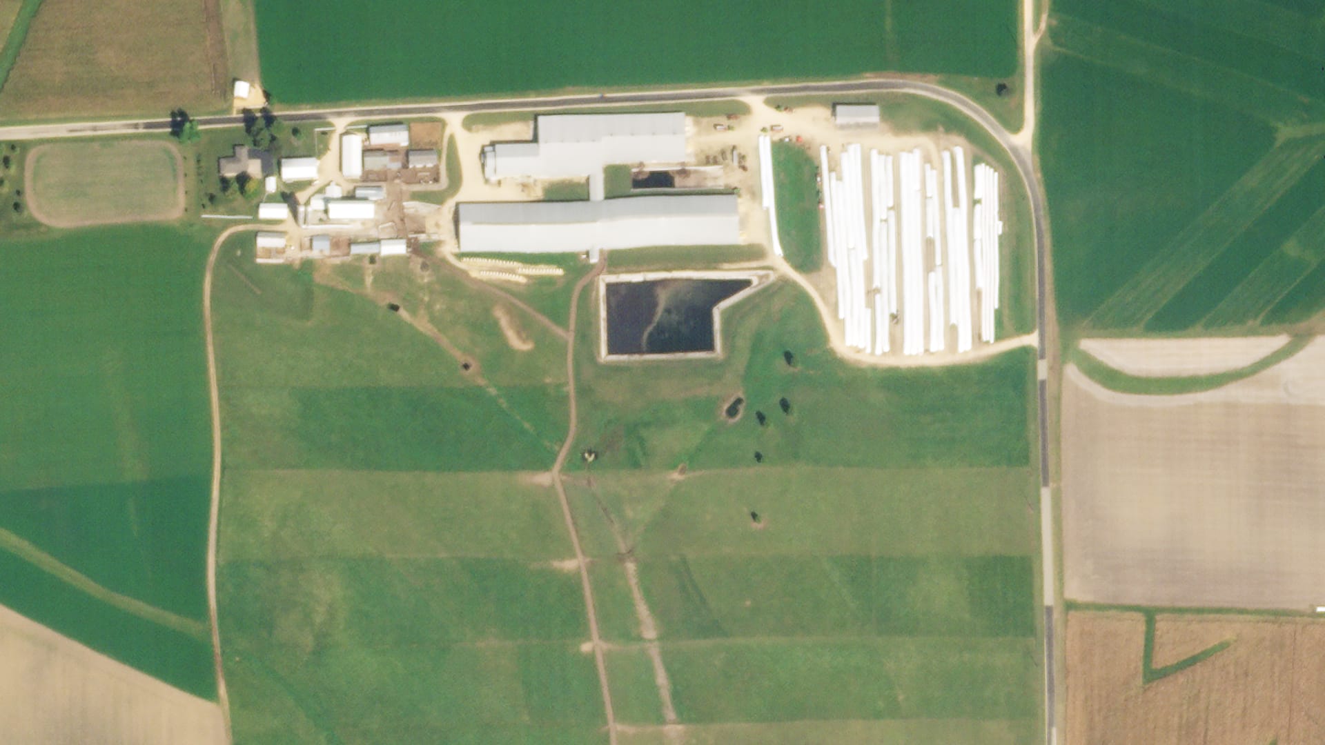
SkySat image of Organic Valley farm in Wisconsin taken September 29, 2021. © 2021, Planet Labs PBC.
Organic dairy giant set to expand on successful pasture mapping pilot
One of the world’s largest organic brands, Organic Valley, teamed up with Planet Labs to develop a pasture mapping tool that’s helped dairy farmers achieve a 20 per cent increase in pasture utilisation.
With intensive rotational grazing a key pillar of the co-op’s production system, maintaining the health of Organic Valley pasture is critical. So too are the near-daily reports now being produced on forage levels – including both pixel-level detail and average values by paddock – that enable farmers to identify trouble spots and determine paddock rotation to protect and improve pasture quality, while maintaining herd nutrition.
Buoyed by positive results, Organic Valley is set to expand the pilot project five-fold this year – offering more farmers the chance to move from time-consuming, subjective manual pasture estimates to efficient and accurate measurements.
- Interested in accessing Planet Labs’ imagery for your business? Find more information here.
The diverse use cases for high-resolution satellite imagery
Beyond agriculture, there are a range of compelling use cases for Planet Labs’ imagery, from monitoring land clearing and tracking oil spills, to ground truthing defence and intelligence activities.
“Governments are using our insights to ensure peace and security, enable natural disaster aid response, and support urban planning and rural development,” explained Tristan. “Non-profits are working on environmental or cultural conservation and humanitarian projects with our data, like Amnesty International, that are analysing illegal deforestation in Cambodia.”
An exciting new use case is Carbon Mapper, a coalition of industry, government, philanthropists, and academia working together to identify and accelerate pathways to mitigate methane and carbon dioxide emissions.
“Identifying point source emitters will be uber critical for the next decade and beyond,” explained Tristan, as the world battles to mitigate the worst impacts of climate change. “With this coalition of partners, we’re developing a first-of-its-kind satellite constellation and cloud-based data infrastructure to detect global methane and carbon dioxide ‘super emitters’ at a facility level.”
Planet Labs’ hyperspectral imaging sensor will be used to provide comprehensive, accurate and timely measurements of methane, carbon dioxide, and over 25 other environmental indicators which reveal the health of the planet. Honouring its PBC mission, the data will be free to access for industry and governments, empowering decision-makers to see, measure and manage the impact of greenhouse gas emissions.
Hyperspectral satellite data offers prime opportunity for farmers
The hyperspectral constellation, Tanager, will offer a whole new world of imaging possibilities to Planet Labs’ users, beyond what is capable with even the highest resolution optical sensor.
This advanced imaging technology does more than spot methane plumes from space. Hyperspectral imaging could revolutionise farm decision-making, too – enabling farmers to differentiate weeds from crops without setting foot in a paddock, or cost-effectively measure soil carbon.
“We are currently exploring several use cases across a few verticals, including agriculture, to drive the most impact with this exciting tool. Our Hyperspectral Team would love to chat with farmers and agrifood innovators who can help us understand where that impact could be.”
Planet Labs is partnering with AgriFutures for evokeAG. 2023 Down to Earth. To learn more about Planet Labs and their commitment to accelerating a more sustainable, secure and prosperous world, visit planet.com or contact Planet Lab’s Senior Field Marketing Manager, APAC, Janeth Fule, here.
evokeAG. will be held on 21-22 February 2023 in Adelaide, South Australia. It will bring the best and brightest together to talk about how innovation and technology collide, intersect, connect, translate, complement, and challenge our most important assets – our people, our farms, our soil, our water and our Earth. Tickets are on sale here.
- View the full two-day program, including all speakers and partners involved in evokeAG. 2023.
Enjoyed this article? Want to learn more about the Asia Pacific region’s innovative agrifood tech ecosystem? Sign up for our newsletter here and receive fresh stories about global leaders, farmers, startups and innovators driving collaborative change.